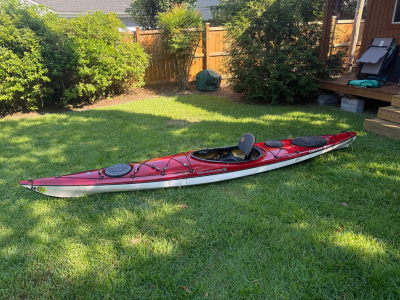
For sale. Wilderness Systems Tsunami Pro 135 Kayak. Spray skirt. Cockpit cover. Paddles. Deck bag. Life jacket. Paddle float. Bilge pump. Full men’s wet suit. All items except life jacket and paddle 1 year old, like new, rarely used, no damage or wear. Life jacket & paddle some wear and fully functional. All pieces new cost $2,120. Sale price $1,000. Will sell individual pieces separately.
Specifications.
Solo sit inside kayak
Hull material composite fiberglass
Length 13 feet 6 inches
Width 23 inches
Weight 48 pounds
Cockpit 35.5 x 19.5 inches.
Spray skirt & cockpit cover
Kayak double Euro paddle
Deck bag & PFD
Paddle float & bilge pump.
Full men’s wet suit.
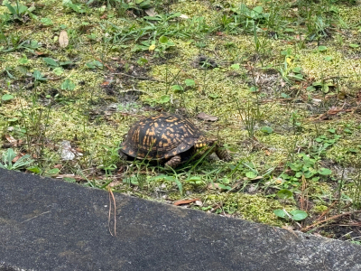
Moss covered ground and bricks and a box turtle at Oakdale Cemetery.
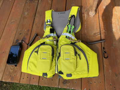
PFD Leashes and Roof Rack Boat Lashes
Several weeks ago, at the Twin Rivers Paddle Club rescue and roll clinic in Martin Marietta Park Lake, I met several people who came to observe. After the class, as I was loading my boat onto the Jeep, they asked me several equipment related questions.
PFD Leashes
The first question was about the hooks and leashes on my life jacket, or personal floatation device [PFD]. In the last four years, I have purchased four high quality PFD’s from Northwest River Supplies [NRS] in Idaho, all because I kept finding more advanced PFD features with better ways to fasten my electronic devices. Of course, attached to the shoulder straps are the whistle and sheath knife.
My GPS is a Garmin Montana 750i, which is abnormally big. I also carry an iPhone 16 Pro Max, which is the largest available cell phone. For carrying pockets, I first used heavy, bulky Army surplus ammunition pouches, because the pockets available on most PFD’s, and the after-market add-on pouches, were too small. I tried attaching the ammo pouches to my PFD, to my deck bag, and to the front deck rigging, but each system did not work in some way.
Every year or so, NRS would come out with a new style PFD with different pockets, and I would buy another one. But the attachment points were weak and poorly designed.
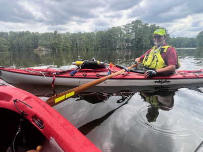
My current (and hopefully last) PFD from NRS is the C-Vest. It is designed for fishing, with two medium size pockets, and two large pockets. Most importantly, it has two sturdy D-rings attached to the two shoulder straps. For anybody wanting to buy a C-Vest, they are now discontinued and selling out. There are a few left in stock. See the picture attached to this article.
I use the D-rings to attach heavy duty brass double clips, and attached to those are springy, expandable leashes. The leashes end in small carabiners which clip to the GPS and phone. The Garmin has a hook built into the case for the carabiner, But for the phone, I had to glue another D-ring to the phone case. While paddling, the two electronic devices ride in the PFD front pockets, and the leashes allow me to pull them out and navigate with them, while protecting them from the risk of me dropping them into deep water and getting lost.
I also carry a VHF marine radio, but only as an emergency backup, so I do not need to pull it out and consult it while paddling. I carry it in my deck bag, with my snack food, water, and poop and pee kit.
Roof Rack Boat Lashes
The rescue class observers’ next questions were about how to load a 50 pound boat over my head onto the Jeep roof racks. I have loaded canoes and kayaks onto vehicle roof racks for 50 years, using about 20 different systems. For my current and best system, see the sequence of pictures attached to this article. Importantly, all the painters (bow and stern ropes) and cross-boat straps are exactly measured, cut and tied or buckled to fit. To move the boats, I do not have to tie or untie any more knots.
First, I lay the boat on the ground with the bow a foot past the Jeep rear tire and the stern directly behind the Jeep. I only lift up one end of the boat at a time, so I only have to deal with half the weight. I set the bow on the rear cross bar kayak saddle, then lift the stern and push the boat forward, until it is even with the front of the Jeep. You can buy roof devices which roll easier, called Hully Rollers. But, I find the boats slide easily enough on the saddles, without the rollers.
The painters are circular loops, which clip into carabiners that I attached permanently to the Jeep front and rear bumper hooks, using metal clamps and plastic zip ties. The length of the painters fit exactly into the carabiners. The cross-boat straps use Ancra buckles, which allow the straps to feed through easily, and then grip like shark teeth, so there is no give and no tightening needed. For extra security, the straps cross over the top of the boat twice, and cross under the racks twice.
While the boat is in use, I run the painters and straps under the bow and stern deck rigging. By good luck – not something that I designed – the ropes and straps fit the length of the bow and stern decks, then clip into the carabiners, without having double wrap them or tie any knots. The same system works on my solo / tandem Dagger canoe.
Shell Island
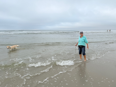
Very early on Friday morning, August 15, Janet, Gracie and I drove to Shell Island at the north end of Wrightsville Beach, NC. Shell Island used to be a real barrier island, but a couple decades ago a hurricane shifted the sand, filled in the southern channel, and made it a peninsula.
We got up at 6 a.m., before day light, because we did not want to go to just any beach. For several years, a few years ago, Janet frequently brought Gracie to Shell Island to play in the surf on the ocean side, and sim in the channels on the estuary side. Now, after a few years of missing it, she wanted to come back.
But now, there has been so much tourist growth and beach house growth, that the last several times we came here, every public beach access parking lot on the north end of Wrightsville Beach island was full, with a couple cars waiting in line, at 6:30 a.m., on a weekend. Most of the beach goers were surfers and stand-up-paddle boarders. This time we went on a week day to see if our luck would be better.
We went to the northern most parking lot at the end of the road, [strangely labeled Lot #2, instead of Lot #1] and it was already 90% full. This lot is the most popular in the area, because it has a nice bath house with an outdoor shower, and the breach is the least crowded. We just squeezed in before several more cars showed up.
The weather was over cast and somewhat dreary looking, but at least we had a break from the nearly non-stop rain of the last couple weeks. We walked north up the beach with Gracie playing in the surf and chasing sea shells. Technically that was illegal, since dogs are banned from the Wrightsville Beach shores all spring, summer, and fall, even on a leash. Fortunately, a town employee drove past and did not give us a citation. Rather, he warned us that another employee who would give us a citation was coming at 8 a.m.
We made it to the north end of the beach and looked across the inlet to the big, expensive houses on Figure Eight Island. Janet considered walking westward around the end of the peninsula and southward following a path through the estuary back to our parking lot, which she used to do. No go. Now there were signs saying Private Property and No Trespassing blocking paths through the estuary. Bummer. I though the estuaries are public places, like the beaches, so I don’t see how they can be marked No Trespassing. So, we walked back down the beach at 7:50 a.m.
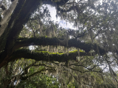
Old, Old Gravesites at Oakdale Cemetery, Wilmington, NC
Spanish moss, growing on ferns, growing on ivy, growing on green moss, and growing on live oak tree limbs. Plus a child’s gravesite among many years’ growth of green plant life.
On August 9 Twin Rivers Paddle Club highly-experienced members Terry Rich and John Burt conducted a rescue and roll clinic on Martin Marietta Park Lake. The students were yours truly Bob Laney and highly-experienced member Ginger Motes. I worked on my heel hook self-rescue with instructor John, while Ginger worked on her roll with instructor Terry.
Ashamedly, I failed to follow my own advice from my prior self-rescue practice. I recently posted a report about my not being able to fit my Euro blade paddle between the deck cleats of my kayak because they were too close together. I stated the good sense rule to test your gear before leaving the house. Today at Martin Marietta, I correctly brought a Greenland blade paddle, but I failed to test it before driving to the lake. Once I was in the water, to my chagrin, my back deck had an upward protruding hump, which prevented placing the Greenland blade under the new, stiff and tight new cords.
John and I had the joint idea to insert the blade under the cords further towards the stern, where the deck does not have a hump, and the cleats are further apart, allowing the cords more room to stretch.
I was right to take this class, because I still did not know what I was doing wrong. My first three attempts failed. The conclusion is that when I did two successful rescues at a clinic last February, I was just lucky. Today, after each effort, John patiently, wisely and kindly made suggestions of what to change. Eventually, I made a couple of complete rescues. But, they were a little ragged and difficult. John advised me to keep practicing, which I will do. I need to smooth out several parts of the procedure, involving keeping my hand on the paddle handle with float for balance but not pushing down on the handle; grabbing the far side static cord and pulling my chest horizontally across the back deck; straightening my legs without pulling down on the cockpit rim with my heel; and rolling into the cockpit while keeping my seat back pushed our of the way. After getting balanced, I need to spend some time pumping a lot of water from the cockpit. I will also practice some cowboy rescues to see how I fare with them.
In addition to what I learned to do better, just as importantly, I learned what I cannot do, and not to push it. After the rescue lesson, John and I tried the first step of a roll. While my lower body remained in the cockpit with the spray skirt on, I held out one hand gripping the middle of the paddle shaft, arm fully extended sideways, and turned myself and my kayak one quarter rotation towards that side. The paddle floated on the water surface, and I put my head and both shoulders flat on the water. Due to my weak and inflexible back, from a 40-year-old- injury I got while trying to learn to roll, just getting in that horizontal position hurt.
Then, when I attempted to roll up vertical, using my lower leg, thigh brace and body core, I could not come close. I could not budge the boat. And, within a few seconds, I developed vertigo. I felt so dizzy and nauseous that I had to immediately get John to pull me up. This series of events repeated three times. John and I concluded that the roll is not a skill that I will develop. And, I should stop trying, so as to prevent a potential further injury.
Afterwards, Ginger commented that her roll is a work in progress.
Terry and John reminded me several times each, the same as they have done in all our prior classes, that paddlers need a lot of flexibility and core body strength. I have set myself the goal every day to do stretches, flexibility exercises, and some committing athletic event, or make a trip to the YMCA weight machine room.
Greenfield Park Lake Cruise
Fairly late Sunday afternoon, August 3, Janet and Bob took a casual cruise around Greenfield Park Lake. We purposefully came here, where there is no tide, no current and little wind, because several of our trips in the last couple months saw us battling difficult conditions. Unlike all trips to Greenfield, we say no alligators and only a few turtles. We did see several water birds hunting game fish.
While waiting for my new Greenland paddle to arrive in the mail, I had been on a couple recent trips using a Euro blade. Today, I used the new paddle and for about 15 seconds it felt strange, without enough resistance to the blade pulling through the water. Then I dipped it deeper, and the feeling was mellow, smooth and good.
Today’s excursion was our fourth trip to this lake since Janet and I began paddling together a couple years ago. We have never been all the way around it. Our plan today was to circumnavigate the lake, both to learn the layout of the bays, inlets, and trees; and to get more exercise. But the best laid plans sometimes go astray.
A third of the way around the lake, my abdomen was suddenly hit with a sharp, deep pain. I had experienced this kind of pain a couple times this year. It meant a fast paddle back to the put-in / take-out, a leap out of my boat abandoned on the ramp, a sprint across the parking lot and driving over the speed limit around the park to the bathhouse. I made it to the Men’s room with two seconds to spare.
Janet stayed on the water until I returned, and played around among the Spanish moss draped cypress trees. I elected not to go back on the water, so we packed up the equipment. Back at home, I felt well enough to clean the boats and hang the gear to dry.

My last practice kayak self-rescue attempt did not work, because of a broken paddle and stretched out deck cords. So, I obtained a new Greenland paddle recommended by Terry Rich. Then I replaced the rear deck rigging with stronger static cord under the guidance of Bill Webb. I studied several YouTube heel hook videos and believed that I identified my improper technique. I was wrongly doing a push-up with one arm on the paddle shaft held up by a paddle float, instead of grabbing the far side static cord and using my other arm to pull my chest flat across the back deck. And, I was pulling down with my foot in the cockpit, instead of straightening out my knee.
John Burt and Terry graciously agreed to meet me at Martin Marietta Lake for another class. But this morning, I decided to save the four hours round trip drive and try again myself at the Smith Creek Lake. I chose to protect my new paddle from getting broken by taking one of my old European blade paddles that I did not mind losing.
Upon doing my voluntary capsize and wet exit, I quickly learned some more lessons.
First, my Eddyline Sitka XT rear deck rigging cleats closest to the back of the cockpit are situated too close together for a European blade to fit between them. In this boat, a paddle float rescue can only be done with a Greenland paddle; or by placing the paddle further back on the rear deck where the boat is narrower and the float will be less effective. So, I will come back tomorrow with my Greenland paddle and try again, being very careful not to break a third paddle.
The second lesson is to test all new gear, and newly configured gear, before leaving the house.
Thirdly, while still in deep water and emptying the boat cockpit of water, I learned that this Sitka does not pour out water nearly as efficiently as my former Nigel Dennis Kayak. The space between the Sitka seat back and the adjacent bulkhead is much wider than in the NDK, so the Sitka retains more water. This extra water sloshing around in the cockpit makes the boat more unstable while trying to re-enter, and when trying to balance while pumping out the water. I may need to practice pumping while my body is still outside the boat. That maneuver will be difficult, but maybe necessary.
After swimming and walking to the shore, I did give my new pump a good, long workout and it performed well.
Besides the self-rescue lessons, I discovered several more improved techniques.
It seems that most of my fellow paddlers do not wear a spray skirt. I feel uncomfortable without mine, like driving a car without a seatbelt. My spray skirt has suspenders, and I pull it up over my legs from below. I found a better way to keep my balance while standing on the shore, and to keep the suspenders and my shirt tail from getting tangled in the waist band.
I also notice that almost none of my fellow paddlers use a paddle leash. I understand the danger of it getting wrapped around my neck or some other bad place. But I am more comfortable using one. For many years I was a scuba diver, so I am used to keeping hoses and cords out of the way, even when deep under water. So, today I discovered a better way to stow the excess middle section of cord away from trouble, while not interfering with popping my spray skirt.
My final new technique is a better way to firmly secure my two wheel kayak cart on the stern deck, without getting in the way of a paddle float rescue.
Finally, a few things that did not operate correctly, and I have not yet figured out, so they are still works in progress.
Most other paddlers carry drinking water in some kind of bottle with a cap or spout. I prefer a bladder with a hose and bite valve. The bladder can be used without taking two hands to pull it out of a pocket and remove the lid; and there is no chance of dropping it into the lake or river and losing it. But, I have not found an insulated bladder. This morning, I filled my bladder chock full of ice and pre-cooled water from the refrigerator. Discouragingly, after only one hour in the sun, all the ice and coldness were gone, and I was drinking unpalatable warm water. I may have to switch to an insulated Yeti bottle, which means having to use two hands to drink.
I also learned that on my nearly new Sitka, the small day hatch cover directly in front of the cockpit, leaks badly. But I cannot see any tear or damage. It looks like a perfect seal. Does anybody have a repair suggestion? Unless I can find a cure, I will continue to carry items in the day hatch inside a roll top water proof bag.
On July 18, Janet and Bob decided to go paddling our kayaks, despite the 94 degrees heat, high humidity and mostly bright sunshine. The day before, we had been to the Wrightsville SUP shop beach to paddle Lees Cut, at the north end of Banks Channel. But, after noting the conditions, Janet decided it was too hot and Bob decided it was too windy, so we did not unload the boats. Today, we could not help ourselves, and went back to the same place with the same conditions.
This time, we put at the bridge, beside the Wrightsville Beach Boat Launch, where US Hwy 74 crosses the Intracoastal Waterway. The NC Wildlife Resources Commission manages a large parking lot and boat ramp here, but for some prejudicial reason, the parking lot is limited to vehicles with trailers, which necessarily means motor boats. Even though the adjacent parking area under the bridge is not improved or maintained, the town or Wrightsville Beach still makes users pay a parking fee. We used the small sandy beach under the bridge to launch into the ICW. Then we paddled north 100 yards and turned east into Lees Cut.
This bay is flanked to the south and east by large houses with docks; to the north by large sea grass beds; and to the west by the ICW. We purposefully went just before, during and after high tide, but did not know which way the current flows when the tide is going in or out. We learned that when it is flowing out, it goes through the Cut to the west, which seems intuitively backwards. The lesson is that local knowledge and experience trumps logic and theory. This current held us back going eastward, and pushed us quickly going westward, making our situation the safest, since westward was towards our take out. We paddled as far as the Wrightsville SUP shop, and disembarked at their sandy beach to sit on the dock and stretch our legs.
After waiting out a very brief but hard rain shower under a handy beach umbrella, we paddled back to our take out, at the put in. Obstinately, the wind blew directly in our face and held us back, going both ways. That condition seems to happen to us more often than the odds would predict.
Only one of us capsized while entering their boat at the mid-trip rest stop, but which one will remain a secret. Either I experienced, or I was told, that the dunking was refreshing. Surprisingly, the high heat and humidity were noticeable, but not oppressive. We never got really sweaty. During the paddle, we both ameliorated the heat by scooping up cool water and splashing it on our backs, necks and chests.
Even though the trip was only 2.25 hours and 2.75 miles, I used two navigation devices for practice. Paddle Ways is a smart phone app sponsored by our paddling equipment friends at Northwest River Supplies on Idaho. It has a beautiful screen, bright colors, easily viewed graphics, intuitive systems, and a wealth of information. Unfortunately, those features mostly work indoors, away from the bright sun, water drops and rocking boats. On the water, it was almost impossible to see the screen or use the features. Worst of all, it would turn itself off every few minutes and stop tracking. To use it again, the user has to wake up the phone, turn on the program, push buttons to find the map page, wait for the tracking to catch up, and then do something, like enter a waypoint, all of which takes about a minute and a half. Meanwhile, the wind and current are pushing the user’s boat off the course, and his partners are leaving him behind. I will continue to use Paddle Ways at the put in and take out for its large amount of information, but not use it while moving.
The star of the navigation show was my Garmin Montana 750i, which is as it should be, since this device costs about ten times more than the phone app. Everything worked well. Best of all, I recently learned how to pre-program serial waypoints. Upon reaching a turn or other important point, I could push one button, instead of five buttons, to mark the spot, correctly labeled and in proper geographical and numerical order.
N 34 13 11.16
W -77 48 32.01
McRae Peak Realization
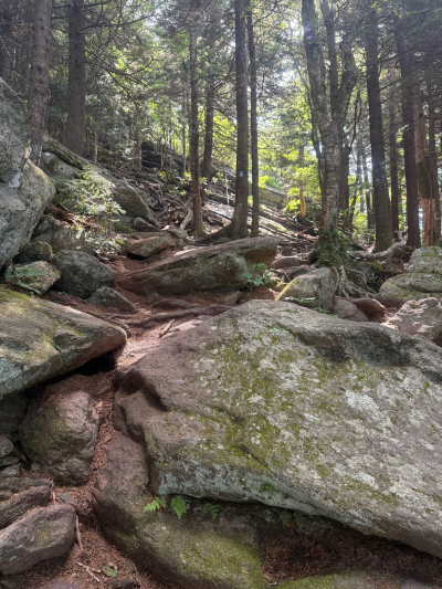
Grandfather Mountain in the Blue Ridge Mountains of northwest NC is my home base. My family has owned a cabin near there since the year I was born. This mountain is my main location for recreation. I identify with Grandfather so closely that my Last Will and Testament directs my executor to sprinkle my ashes on the Boone Scout Trail. In case that action is illegal, I warned him to keep an eye out for the law.
I have hiked and backpacked all over the NC mountains and know most of the trails. The Grandfather Trail is the most rugged and has the most exposure. My pictures of the trail in this social media post do not do justice to the steepness. The small camera lens and the perspective makes the trails in the photos look fairly benign. There are numerous places which I did not get to this day [no photos] where a slip and fall can be fatal.
I have hiked and backpacked on every trail all over Grandfather Mountain beginning at the age of 12 years, and for the next 60 years, close to 100 times. During my family’s annual July 4th reunion and holiday this year, I hiked the Grandfather Trail, traversing from the Grandfather Mountain private attraction to the State Park, starting from the Black Bear Trail parking lot (below the Swinging Bridge) towards McRae Peak, at over 6,000 feet altitude.
I have traversed this particular section of trail probably 30 times. But I had not been here in about 15 years. And in the interim, I have had surgeries for both hips and back, and many major muscular and skeletal injuries, followed by long stretches of recuperation. The result is years of insufficient exercise. My physical strength and stamina have deteriorated.
After living in the western piedmont NC and in the Blue Ridge Mountains most of my life, several years ago I moved to the NC coast. This trip going back to the mountains was a kind of reunion.
On my drive to the trail that morning, I had the first inkling that things were not the same as they used to be. For my entire life, I have carried a map in my head of everything in the mountains – roads, intersections, towns, stores, creeks, valleys and mountains. I never had to think about what is the route to anywhere I want to go. About half way between the cabin and trail head, I was driving, and I had a moment where I had to pause and think, where am I on the road, and which is my next turn?
The trail climbs moderately, and then steeply. It consists of dirt, rocks, mud and roots, with occasionally cables and ladders on the cliff sections. After getting about 2/3 of the way to McRae Peak, I had the realization that the steepness and roughness was more than I had remembered. As I progressed up the trail it got steeper and rougher. Many places had no trail, just areas of boulders to be climbed over, around or under. The height of the climbing sections, the verticality of the slope and the ruggedness of the places to step or grab exceeded my memory of those places.
Eventually, I felt that the trail difficulty was more than I could physically handle. It took somewhat more strength, endurance and balance than I thought I had. I felt that I would not be able to make it to the top. At the cliff face where I stopped hiking, I recognized the location with its cable, and I knew exactly where I was, but it looked strangely tougher, steeper and taller than I remembered. I felt overwhelmed with the work I would have to do to complete the climb. So, I sat down to contemplate things; and I started composing this written trip report in my head.
One sad factor is that work I did today which tired me out was about 2/3 of the trail from the Black Bear Trail parking lot to McRae Peak. That work was only about 10% of the work I had done many times when I was younger, by starting at the bottom of the mountain on US Hwy 221 or NC Hwy 105, climbing the entire mountain on the Boone Scout Trail or the Profile Trail, crossing the Calloway Peak, Attic Window Peak and McRae Peak, at about 6,000 feet altitude, then going down to the Swinging Bridge, then turning around and going back the entire way I came, in one day. One such prior trip was solo, in early December, with ice coating the trail and 90 mph wind blowing at the top.
Driving back to the cabin, I looked out on the beautiful mountain scenery to the southeast. I had a sad feeling in my gut that it is still beautiful, and I can come to visit it whenever I want. But I felt an emotional distance. I was fading mentally and physically. I can’t do all the things I used to do. I am no longer 100% a part of the mountains, and they are no longer 100% a part of me. I felt some actual grief.
I was reminded of my prior backpacking trip about ten years ago, aged in my early 60s years, with Jim Smoak Hank, Perkins and Kelly Pipes on the Appalachian Trail from Roan Mountain, TN, through Carver’s Gap, and over the multiple grassy balds of Yellow Mountain and Hump Mountain, to US Hwy 19 E. I have been there multiple times and loved the place. While hiking up the extremely long, steep trail on the north side of Hump Mountain, I almost gave out and was going extremely slowly. The other guys waited for me at the top for a long time. I could tell even then that my strength and endurance were somewhat reduced from prior years. I had the sinking feeling that this may be the last time I ever see this mountain top. Unfortunately, I have not been back.
After getting back home to Wilmington and chatting over the situation with Janet, I decided that things are not quite so bad. After some physical training and mental planning, I will go back to Grandfather Mountain later this summer. Using my better realization of what I will be facing, and my better mental preparation, I will take the same trail again and I will reach McRae Peak. Stay tuned for a later installment of this post.
N 36 05 43.50
W -81 49 45.93