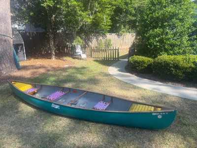
Canoe specifications
Canoe is lightly used, some wear, no damages, always stored indoors
Royalex light hull
Length 15 feet 4 inches
Width 34 inches
Weight 55 pounds
Color Caribbean green
3 seats for tandem or solo
Cane woven seats replaced with nylon webbing
Wood gunnels, decks, seats & thwarts, treated with wood preservative
Flotation air bags in bow & stern
Cost new $2,000
Used price $900
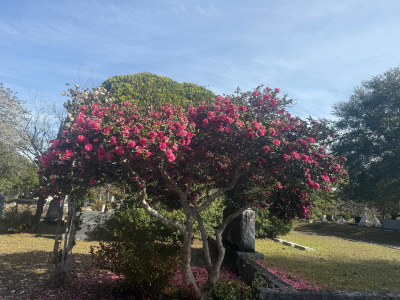
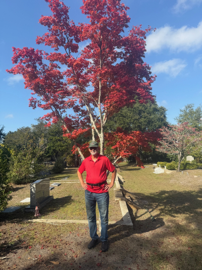
During many early morning trips to Oakdale Cemetery in our neighborhood by Bob, Janet and Gracie, we saw a nearly endless series of blossoming trees and bushes, mostly camelias which bloom all winter and into early spring.
I was not able to get photos of our many wild animal encounters. We saw a beautiful, healthy adult red fox loping across the grave sites; flocks of ibises which are normally seen in salt water estuaries and not this far inland; fur on the ground evidencing a fight between a racoon and some other fierce animal; and the mostly chewed hind leg of a whitetail deer.
The photo of Pembroke Jones' grave marker is to show the burial site of a former wealthy citizen of Wilmington, NC, for whom the common phrase "Keeping up with the Joneses" originated.
The photo of Henry Bacon's grave marker is to show the burial site of the architect who designed the Abraham Lincoln Memorial in Washington, NC.
The photo of David Brinkley's grave marker is to show the burial site of one half of the famous TV news reporter team of Chet Huntley and David Brinkley in the 1960's.
I also don't have photos of two more important citizens buried in Oakdale, but Janet and I have often walked past the site of the man for whom McRae Peak on Grandfather Mountain is named; and the man for whom Kenan Football Stadium on the UNC Chapel Hill campus is named.
And, as you can see, I love to look at and photograph big, old, moss and ivy covered live oak trees.
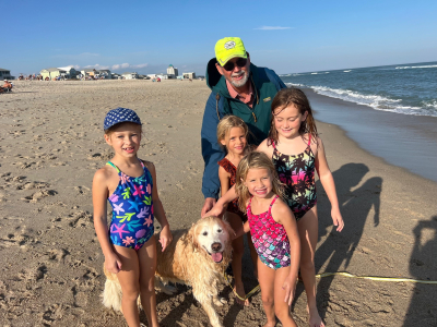
In late autumn 2025 Janet, Bob and Gracie took an afternoon trip to Wrightsville Beach north end. While there, we had the good fortune to encounter a wonderful group of little girls who loved to pet Gracie. Everybody had fun together.
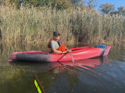
Lake Sutton Last Paddle of 2025
In late fall of 2025, Janet Smith and Bob Laney went on our last paddle of the year. Bob paddled his sea going Eddyline Sitka XT kayak which he had for a couple years. Janet had recently switched back from her newer and sleeker Wilderness Systems Tsunami 135 Pro to her older Old Town Trip 10 Angler, with which she was more familiar and comfortable.
We had seen Lake Sutton on maps a few miles west of Wilmington, NC. It was the cooling lake for a nearby electric power station. Upon turning off the main highway onto the long paved driveway, we discovered that it had an idiotic number of steep asphalt speed bumps spaced every few yards for a couple miles. At the end of the driveway was a huge NC Wildlife Resources Commission parking lot painted for motor boats and trailers. Strangely, it was empty, even at late morning on a warm, sunny day. My experiences at most other river, lake and ocean side parking lots in this part of the state are that they are always full of pickup trucks and trailers, from dawn to dusk, year round.
We later learned that the lake contained chemicals from the power station which semi-poisoned the fish. A local law limited the catch to just a couple fish per day, so nobody wanted to fish, paddle or motor boat here.
We put-in at the dock and ramp beside the parking lot. Janet and I had a leisurely paddle around the perimeter of the lake. The lake was surrounded by swampy areas, concrete walls and thick brush. There was nowhere to get out of our boats and onto the shore for our picnic lunch. We saw almost no wildlife. After a couple hours, we decided to head back to our put-in for our take-out and go home. We took a short cut and paddled straight across the middle of the lake. As luck usually has it, just as we started across the lake, a strong wind blew up directly in our faces, trying to push us backward. So, we got a good physical workout paddling to the ramp. This trip will probably be our last one here.
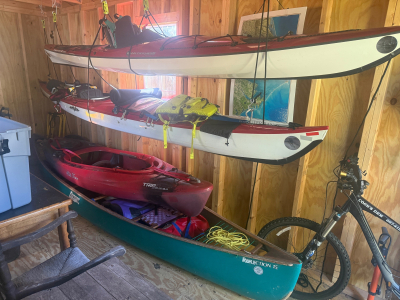
Can’t have Too Many Boats, Bicycles or Packs
An outdoor sporting couple like Janet Smith and Bob Laney cannot have too many boats, bicycles or packs.
Fall Colors and Old, Old Grave Sites
While on many morning trips in the last month to Oakdale Cemetery to walk, throw sticks to Gracie and occasionally ride bicycles, here are some of the beautiful and thoughtful sights we experienced. Some fall leaf foliage, some late blooming flowers and bushes, and old grave sites. A few of the grave stones showed persons who were born in the late 1700’s.
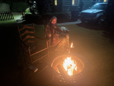
Back Yard Fire
In mid-October, Janet and I made our first fire of the Fall. Gracie joined us in the backyard. Several people asked us, but no, we did not make S’mores. We used to that a lot, but we are trying to cut back on our calories.
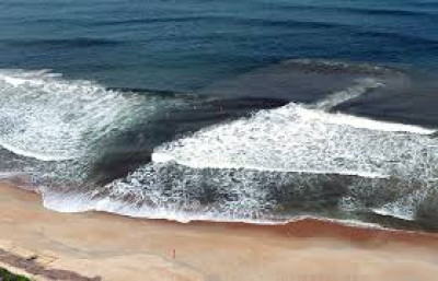
Rip Currents
Sometime in September of this year, Janet and I were at Wrightsville Beach. I noticed as the tide was rising that the waves coming in and current washing out were changing. A trough in the sand was forming at the farthest reach of the waves. The water in the trough was not smoothly running back into the ocean in a broad sheet, but instead running down the trough towards one end. The returning water was making a small, narrow current back into the ocean. The incoming ocean waves were making different patterns in different directions, with some waves going backwards into the ocean.
Over time, the tide got higher, the trough got deeper, and the returning current got stronger. Kids were playing in the trough and running with the current into the ocean. Their parents were ignoring them. I said to Janet, “That trough is the beginning of a rip current. Eventually, those kids will be in danger.”
After a further while, a loudspeaker on the shore made a public service announcement that rip currents were forming on the beach, so for swimmers to stay out of the water. Some people complied, and other persons stayed in the water.
Then, a little later, right in front of us, two swimmers were seen struggling in the rip current to get back to the shore. Two lifeguards drove up on 4 wheeler carts, jumped in the water with life-saving buoys and towed them in.
Many persons do not know two easy self-rescue techniques. One is to easily and casually swim to the left or right, parallel to the beach, about 30 yards, or even less. You will be out of the rip current. Then easily and casually sim to the shore.
Or, stop swimming and float to just past the ocean waves. The rip current will dissipate. Then swim parallel to the beach and into the shore. Unfortunately, some people do not know these techniques, and each year a few drown.

Merchants Millpond State Park Kayak Camp
On October 3 – 5, Friday through Sunday, following leader John Burt, Twin Rivers Paddle Club and New Bern Outdoor Adventure Club members Bob Laney, David Whitlow, Zadock Dismuke and Diana Hastings kayak camped at Merchants Millpond State Park in northeastern NC just south of the Virginia border. We put into Lassiter Lake at the ramp and dock beside the main parking lot early afternoon and paddled across the lake to our back-country paddle-in group camp site reserved by John’s wife. On the water we were mostly led by David.
Partial areas of the lake were totally covered with duckweed. For some of us, it clung to our paddles after every stroke with a couple pounds of wet plants. I was using a Greenland paddle, so the long straight blades made swiping off the weeds with my hands a little easier.
Following the marked paddle trail across the lake and through the swamp was not particularly easy. The buoys marked with colored bands were large, but some of them had fallen over sideways, making them less visible. Another problem was that they were spaced too far apart, with the view from one buoy to the next one often blocked by trees. On the trail between buoy 3 and 4 the correct route was a narrow channel without the next buoy in sight. There were several large open areas of water in other directions. There was nothing intuitive to guide the paddler through the narrow channel. After entering the channel, going halfway through and making a curve, there in sight was the next buoy. It is not a good trail marking system.
David and John knew the route by memory. But I could not navigate the trail without some assistance. Before the trip, I reviewed many GPS’s and smart phone navigation apps and Internet park maps. The paddle trail did not appear on most sources. It is shown on only three places: the state park web site map, the smart phone app Natural Atlas and the Garmin Montana 750i.
Finding the camp site was another challenge. There is a sign on the bank of the lake identifying the several camp sites, but their view from the lake is blocked by shore line trees. There is not a ramp or dock. Again, without some other source of guidance, it would be close to impossible to know where to take out.
Upon landing at the bank below the camp, we beached our boats and made multiple trips carrying our gear about 100 yards on a woods trail to the designated area. The level, open woods could accommodate dozens of tents, so we spread out. Most of the time, we ate quick, simple meals. Some were sandwiches, some freeze dried meals and some simple cooked food.
Both nights, John led several campers in gathering a large supply of firewood. Each night we had a nice, big roaring camp fire. The camps had no running water or electricity. Most campers bring their own water. I pump filtered some water from the lake, which worked and tasted fine. The campsites shared a roomy, quaint, wooden outhouse with a moss covered wood shake roof. Our campsite had to cross a neat looking wooden foot bridge over a corner of the swamp to get to the outhouse.
Saturday morning most of the campers hiked several long trails around the park. Bob stayed in camp and did legal work for law clients, editing documents he had transferred from his office computer to his iPhone [a trick not documented in the Apple brochures].
Saturday afternoon we all paddled around the lake. We saw fairly closely the tops of two big alligators.
We encountered on the lake multiple times members of a large group of students from a local college outdoor club, who were doing the same thing as us. Despite their lack of experience [two paddlers in one canoe drove straight into a live tree trunk] they were wonderfully disciplined and behaved. They made almost no noise. They set up camp Saturday evening and departed Sunday morning quickly and efficiently. I suppose they had a good leader.
For dessert Saturday night. David brought, and Diana and Z carried in their canoe, an iron Dutch oven with a lid, and a bag of charcoal. David mixed up and cooked a scrumptious berry cobbler. It was enjoyed by all.
Sunday morning, we also departed camp quickly and efficiently. Paddling back across the lake on the now familiar trail seemed to go quicker than going out Friday afternoon. Thanks John. We are looking forward to the next great adventure.
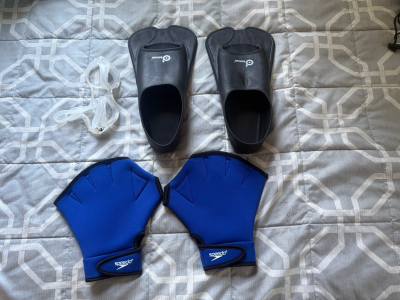
Kayak Swim Kit
I had an idea. When I go kayaking, in the unlikely event that I capsize (which has not happened yet); and in the further unlikely event that I cannot do a self-rescue or tandem-rescue (I have done several of both), then I may have to swim to shore. I have configured the ropes on both ends of my kayak to loop over my shoulder, so both my hands are free to swim.
The idea is, I have some swim aids that I use at the YMCA pool, which increase my speed, including goggles, webbed gloves and short fins. I will put them in a stuff bag, and when I go paddling, I will stow them in a kayak hatch.
Maybe I am over-thinking this situation. Who knows? Maybe someday I will be glad I have them with me.