Sims Pond / Green Knob Trail
This hiking trip was part of the larger 2025 annual week long Laney family reunion and July 4th holiday at the family’s two Blue Ridge Mountain cabins on Shull’s Mill Road in Watauga County, NC. Each year some of us take one or two fairly rugged hikes in the nearby mountains.
Some years ago, when we were younger and tougher, we would do extraordinarily long and committing hikes, like all the way from the bottom of Grandfather Mountain at NC Hwy 105 or U S Hwy 221, up and over all three peaks at 6,000 feet altitude, then to the Swinging Bridge, and back to the beginning. Or, from the ridge atop Linville Gorge at Kistler Memorial Highway, down and around in Linville Gorge and back up to the beginning.
Our current ages range from the mid-60s to the mid-70s years. As we have gotten older, we have shortened the trips, but we still go somewhere with plenty of nature and the outdoors to experience.
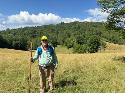
This year, brother Frank led siblings Jack and Bob, brother-in-law Larry and grandson Isaac on the Sims Pond / Green Knob trail. It makes a big loop just north of Price Park, goes around Sims Pond, climbs Green Knob and crosses the Blue Ridge Parkway twice. The upper (higher altitude) side of the trail happens to pass near one of the Laney cabins on the far side of a cow pasture. Frank knew of a cow path through the pasture connecting the cabin to the trail.
The trail starts a hundred yards south of Sims Pond, on the west side of the Parkway, and dives directly into deep woods. Following it clockwise, it soon steeply climbs a dirt, rock and root path up Green Knob. On the other side of this mountain, it crosses some grassy meadows where the cow path goes to one of the Laney cabins. Then it follows a creek fairly steeply downhill, under the Parkway, and feeds into Sims Pond.
Before the trip, I had a couple of dilemmas. Take hiking my staff or leave it at the cabin? Wear a long-sleeve shirt and pants or shorts? I opted to take the staff, which was a very good decision. There were numerous places on the trail that were so rough, or steep or slick that I would have been in trouble without it. Then, I chose to wear long pants and shirt, and found it was a mistake. I got way too hot. Oh well, you win some, and you lose some.
I had hiked this trail once several years before and remembered it as fairly simple and benign. My memory was way wrong. Parts of the trail were extremely rough and steep, and kept going that way for a long time.
Some of the ruggedness was because of the mountainous terrain where the trailer is located. Other sections were made more difficult by the hurricane Helene damage last year. It had scoured out big sections of dirt, exposed large rocks and roots, damaged steps, and toppled trees across the trail.
My Garmin Montana GPS reported that we covered four miles in three hours and gained 800 feet altitude. This information does not sound like much of a big hike. But given our ages, it was all that we wanted to do. We were glad to get to the top of the cow pasture and return to the cabin for soft chairs, drinks and food.

Kayak Self-Rescue Practice Broken Paddle – Again
Several months ago, I did a kayak self-rescue practice in Smith Creek Park Lake, using a two piece wood Greenland paddle with a fiberglass collar in the middle of the handle to join the two blades, which I got from my good friend Bill Webb. I had an air inflated float on one paddle blade; and the other blade braced under the rear deck cords. My method was the heel hook, putting my foot inside the cockpit rim, and rolling into the seat. I broke the paddle at the collar.
Then, soon afterwards, I took a rescue clinic with the TRPC in the New Bern YMCA pool, using a much heavier handled, one piece, solid wood Greenland paddle. Under the wonderful tutelage of John But, I was able to successfully do two heel hook self-rescues.
So, yesterday, using the same boat, deck cords, paddle and float, I did another self-rescue practice at Smith Creek lake. The only things that changed were I was trying out a set of nylon webbing boat steps hooked with NRS extra-large carabiners to my paddle; and I had lost about 25 pounds of weight. My practice failed for multiple reasons.
First, the boat steps were no help. When I put my weight on the bottom step, I could not keep it under me to step up. My feet floated out in front of me and gave me no lift. So, I will stop carrying it in my kayak deck bag. My next experiment will be to try it with my canoe.
Second, the deck cords stretched too much and would not hold the boat level. As I put my weight on the near side cockpit rim, the boat rotated 90 degrees. The bottom edge of the rim started to take on water, when I quit pulling on it, and let the boat settle back down flat. So, I moved the paddle to another part of the deck cords which had less flex.
Third, the boat rotated 90 degrees again. From that position, I could not see the float, but since the boat deck was vertical, I believe the float did not have enough lift to hold me up and went under water. I blew up the float’s two chambers as tight as they could go and tightened the strap on the paddle handle.
Fourth, I tried it again. The boat rotated 90 degrees. Then the thick, heavy paddle handle broke cleanly in two. My motions were extremely efficient, with my thigh and stomach tightly against the cockpit rim, and my shoulders flat on the stern deck. I cannot mount the boat any more cleanly.
Wisely, I chose to do the practice at a place in the lake with a firm, sandy bottom and fairly close to the shore. I only had to tow the boat and swim a few yards to reach the bottom with my feet and walk to the shore. Luckily, I was at a trail which led between long sections of thick brush ringing the lake up to a paved path. Further luckily, I had my wheeled boat cart with me. The final work of the afternoon was to pull the boat on a half mile, mostly uphill slog to the parking lot.
This bad development makes no sense to me. The situation should have been a better self-rescue, not a worse one. It makes my future paddle trips unsafe and troublesome, until I can find cures for these problems.
The four main culprits appeared to be:
I hope some of my readers can offer me advice. Thank you in advance for your time and attention.

Pump Filtering Muddy Water
Some of my readers may remember a couple months ago, I published an article about my backpacking trip to the Copperhead Shelter on the Neusiok Trail in Croatan National Forest. One of the problems was the allegedly potable water reported to me by a Forest Ranger was actually a swamp. The water was so full of muddy sediment that it clogged the filter of my MSR Guardian pump within less than a minute after obtaining less than a cup of water.
I called the Mountain Safety Research service department and complained that their $400 pump, advertised to be the best on the market, should be able to handle muddy water, which is prevalent all over the world. But it does not do so. The nice technician on the phone referred me the Millbank water pre-filtration bag website at https://www.millbankbagsusa.com/. The technician reported that many other MSR customers found it to be a good product. I tried it and it worked.
It is a simple cotton canvas bag with an open top and a pointed bottom. There are two sizes, five quarts for $26 and 1.5 quarts for $20. Scoop or pour muddy water into the bag, hang the bag on something with the attached cord, set a catch bowl underneath, clearer water [NOT yet disinfected] drips out into the catch bowl. Sediment stays in the bag.
Then use a filter pump, chemical tablets, boiling or other purification method on the water in the catch bowl to make it potable.
For backpacking, the catch bowl needs to be light and fold down small. The best product I found is a dog travel water bowl from the Wilderdog web site at https://www.wilderdog.com/products/backpacking-bowl. I got the Backpacking Bowl for $18. See the attached photographs.

On a bright, hot, sunny day in late June, I was on Greenfield Park Lake and had my most extensive sighting of an alligator. It was a small one, but it swam around me, sometimes just above the water, and sometimes just below the water, for about five minutes.

On June 21, Janet Smith and Bob Laney kayaked a small part of the Cape Fear River. We launched from the dock and ramp at Dram Tree Park, under the US Hwy 17 Business bridge over the river, at the west end of Castle Street. Our trip took us beside the downtown Wilmington, NC, waterfront and along the River Walk boardwalk.
We started paddling upstream (north), which was deceptively easy. We were going with the rising tidal current about two hours past low tide, with no discernable river (gravity) current. We passed many walkers, large yachts and luxury condo’s.
Our turn-around was about three miles upstream, at the US Hwy 74 bridge. We knew that upon reversing course and heading downstream, the tide would be against us. But, I naively hoped that the river (gravity) current would counter-act the rising tidal current.
It did not.
At the upstream bridge, the river banks narrowed, which made the current faster. I immediately recognized for the first time the strength and speed of upstream tidal current. Adding to our problems was that heading back to the take-out [at the put-in] the weather report was wrong. Instead of the 5 mph predicted wind, we encountered many prolonged situations with 10 - 15 mph winds directly against us.
The paddling was so hard that I could barely make headway. Janet was not strong enough to make any headway. She was mostly standing still relative to the river bank, and occasionally going backwards.
Luckily, just the day before, I had re-configured my kayak rear deck tow rope so that I could deploy it without having to beach and exit my boat. Where we were, there was no beach – just several miles of six feet high vertical concrete and timber walls lining the river bank.
Upon hooking to Janet’s boat, the tidal current pushed us upstream so fast that we bumped into the curved bow of a huge metal barge. I steeled my nerves and prayed that neither one of us capsized. I had a terrible concern that we could be pushed under the barge by the current, get caught on something and drown before we escaped. Within a few seconds, I got our boats oriented downstream and pulled us away from the barge.
The next hour of paddling with all my strength and all my determination, pulling two boats for three miles against a relentless tidal current and a heavy wind, took tremendous exertion. Lately, I have been going on paddling trips to build up my endurance, so sometime in the near future I can paddle with my Twin River Paddle Club friends from the Beaufort waterfront to Shackleford Banks. I don’t know how today’s Cape Fear River paddle will compare to a Shackleford trip, but I certainly got a good workout. We hope to see everybody on the water soon.

On the long weekend of June 13 – 16, a few members of the Twin Rivers Paddle Club and the New Bern Outdoor Adventure Club joined leaders Terry and Becki Rich at Goose Creek State Park, near Washington, NC. The park is located at the junction of Goose Creek, Flatty Creek and Pamlico River.
We camped in the front county campground. Terry and Becki stayed in a tent at a lovely site in the primitive section surrounded by a mature forest of tall trees. I also used a tent, but stayed in the RV section, since those were the only sites with electricity, which I needed for my CPAP machine. The Richs and I shared a couple of neighborly visits at their campsite. We exchanged Becki’s homemade brownies for Janet Smith’s homemade granola snacks.
The weather was mixed, mostly hot, with intermittent wind. Rain varied from heavy in short bursts, to moderate, to none with bright sun.
Saturday morning Terry and Becki lead a kayak paddle trip on Goose Creek, launching from the beach between the public dock and their campsite. I did not go on the paddle, because I had some strong physical soreness, due to ailments which I am now treating.

When Janet, Gracie and I go to Oakdale Cemetery for out daily walk or bike ride, we usually go along the lanes and paths. But one day last week in early June, we encountered the hottest and most humid day of the year, so far. We looked for shade. The gravesites between the lanes had more trees, so we wandered among them. Fortunately, the breeze was decent and was not hindered by the trees.
The gravesites are mostly raised above the paths, which gave us more exercise walking up and down between rows. For some reason, when following us, Gracie does not keep in the lanes. She seemed to enjoy staying near us on the raised areas.

There are four main city and county parks around Wilmington where Janet, her dog Gracie and I frequently go – Smith Creek, Greenfield, Long Leaf and Halyburton. Two have small lakes where Janet and I paddle; Gracie only swims at Smith Creek, because Greenfield has alligators. At all four parks we ride our bikes. I had only hiked at Smith Creek.
In early June I went to Halyburton Park and decided to hike, because some of the trails thorough the woods are made of sand, which makes it somewhat difficult to pedal my bike. I also wanted to train for my next backpacking trip in a few weeks. This foray into the woods was my first time hiking in several months.
The first issue was the heat. I started sweated strongly, but the sweat did its job – it cooled me down some. After feeling uncomfortable for about five minutes, I surprised myself by acclimating fairly well.
The next issue was some of my muscles had not been used in a while. Again, after about 10 minutes, my body got used to the sensations. The soreness did not disappear, but it subsided, and I was able to keep hiking at a decent pace. It actually felt good to stretch some and push some.
The final issue was boredom. I was so used to the scenery whizzing by on my bike that I did not want to watch the trees creep past. It just took some attitude adjustment. I started paying more attention to the details in the forest, and my mind settled into the rhythm of hiking.
I believe that hiking is a better all round exercise than biking. But biking operates at a cooler temperature, and is more fun, so I will keep doing both.

On the bright and sunny morning of Tuesday, June 3, about 15 solo kayakers and two tandem canoers met at Core Creek Landing, near Dover, NC. We were members of the Twin Rivers Paddle Club, under the able leadership of Carolyn Borgert. Our group had a few boats with spray skirts; some open cockpits and sit-on-tops; and a foot pedal boat.
To reach the meeting place at the put-in, I had a two hour drive north from Wilmington. I programmed my Jeep’s GPS to avoid the large highways and take the scenic route. The small, two-lane country roads had views for many miles of beautiful rural scenery, old farm houses, faded barns, groves of pecan trees, field crops, forests and swamps.
Core Creek is a tributary of the Neuse River. It extends upstream into a cypress and tupelo swamp. Some places it is shallow; and is alternately lined by, or interspersed with, stands of trees.
We went upstream three miles. Near the top of our run at a concrete ramp, we stopped for a snack break. The ramp curved downward precipitously as soon as it entered the water, making for bad footing and a poor landing spot. Some of the smarter paddlers [not me] debarked on the dirt shore adjacent to the ramp. About a third of the paddlers got out onto the shore to stretch out; and about two thirds stayed in their boats. Upon returning to the take-out, the same place as the put-in, we had traversed six miles and spent three hours on the water.
There was a neighborhood dog which chased us upstream for a couple miles. It was so energetic that several times it swam across the creek to reach drier sections of woods with better footing for it to run after us.
The whole trip had some mild current. I noticed that the current increased as we moved upstream, where the channel was narrower. The water also felt a little cooler than the places I had paddled recently near Wilmington, NC. Mostly there was no appreciable wind. One time, for a few minutes, it blew directly downstream. Unfortunately for me, this contrary wind was pushing me back right at a spot where my boat was dragging on the creek bottom, making me get stuck for half a minute.
The most interesting feature was the semi-swamp through which the creek coursed several times. Some of those places had no visible route, so us less experienced boaters closely followed Carolyn or Terry Rich. Carolyn commented she had been here about 15 times. I could discern her expertise, because some places the route ran between certain trees with no more than a couple inches clearance on each side of our boats. She seemed to have memorized the location of every tree in the swamp.

In late May, Janet Smith and Bob Laney paddled our kayaks in Greenfield Park Lake. In times past, we were bothered by excessive algae plant growth in the water, which clung to our paddles and hindered our strokes. Today, the water was clear of plants. The lake is a miniature swamp, with trees in the middle, which makes navigation a little bit difficult. It is easy to go through or around the trees, but you can’t see past them to discern where you are on the lake, relative to the put-in and take-out. To keep us oriented, we paddled in a big circle around the shore of the lake.
We have seen alligators here before, but not nearly so many as today. We encountered about a half dozen of the scaly denizens, including a big on about five feet long sunning on a log at a small island in the middle of the lake. On one occasion, Janet was next to the shore exploring a small inlet, when a gator launched from the bank next to her and swam right by her boat. Yes, she yelled!
My goal is to return here and paddle through the middle of the lake a couple times, to learn the topography, and prevent getting lost on future trips. I also need to test to Terry Rich’s solid wood, one piece, Euro blade, 90 degree feather kayak paddle, and see if I want to keep it.