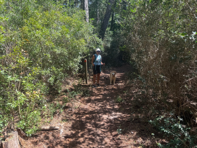
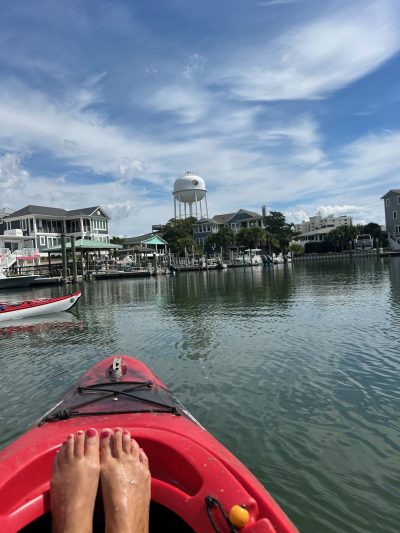
During September 16 – 17, 2025, I went on a backpacking trip to Dogwood Camp on the Neusiok Trail in Croatan National Forest. John Burt’s directions previously given to me for driving, parking, hiking, camping and getting water were perfect. Everything was exactly where it was supposed to be. Thanks John! I parked in a small lot beside NC Hwy 101, across the road from a small wooden foot bridge, one mile south of the intersection with NC Hwy 306.
Dogwood camp is a fairly well maintained Appalachian Trail type shelter. It is only 0.75 miles from the parking lot. The side trail to the camp is marked with a wood sign. Unfortunately, based on the graffiti they left behind, a couple of teenage boys madly in love with some teenage girls totally vandalized the place by writing words in white chalk words on every exposed board. Unlike other northern sections of the Neusiok Trail, which had some hills and stream crossings, this section was flat and dry. Also, this section followed part of the Mountains to Sea Trail, so the trail markers nailed to trees were a silver strip of metal; and an orange disk with a silver arrow. All the trail sections I have seen so far are well cleared and easy to follow.
My pack weighed 40 pounds, which is about 15 – 20 pounds heavier than many ultralight backpackers brag about on Facebook. My heavy pack is due to mostly to my advanced age, after several surgeries, so I carry a CPAP machine, which runs on a heavy battery; hearing aids, cell phone and GPS which need another heavy battery to recharge overnight; a chair for my weak lower back muscles; the best (and heaviest) water filter on the market; a substantial first aid kit and repair kit; and a Springfield Armory 10 mm 1911 pistol.
Two of the three persons I met were hikers, a formerly British father and son, who are now members of the Carteret Wildlife Club, that were doing trail maintenance. They were friendly, and helpful to me. They answered many of my questions with information about the Neusiok Trail, three shelters and water sources.
The other person I met hiking was a middle aged Latina lady. Often when I am on an outdoor trip, other hikers, campers and paddlers I meet stop to ask me questions. Apparently, my appearance inspires their confidence that I know what to do. I call the activity being Ranger Bob. This lady did not have any information about the trail and was just walking randomly down the path about a half mile from the parking lot. I showed her my map, got her oriented on the trail and suggested where she could hike.
A surprising feature was a wooden footbridge over a marshy section. Over the years, I have traversed many of them. But this one was totally wet and in full shade. It had some kind of algae growing on it that was as slick as real winter ice. Even using my two hiking staffs and walking with slow, short, baby steps, I still slipped off a couple times.
Several months ago, when I camped at the Rattlesnake shelter on the Neusiok Trail, I reported water was a severe problem. A US Forest Ranger told me that the water there was potable, so I did not bring any It was so muddy as to clog my pump and be unfilterable; plus, it was tidal influenced, brackish and tasted terribly of salt. So, this trip, I was also did not bring water and was apprehensive of what condition I would encounter. About 30 yards downhill from camp was a spring of fresh water, like John said. It was covered with all kinds of tree leaves, sticks and pine needles, but it was perfectly clear and tasty. It filtered well and I got 4 liters in a few minutes, which was enough for my overnight trip. Both John and the CWC hikers let me know that if the spring water was not sufficient, I could stay on the main trail a couple hundred yards past the shelter turn off, to where a bridge crosses the West Prong of Morton’s Mill Pond Creek with fresh water.
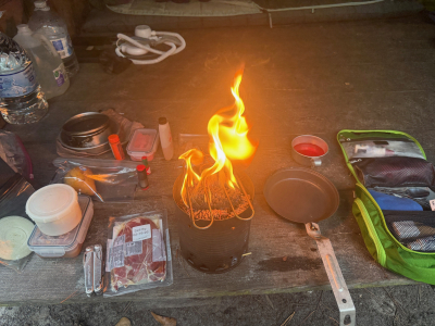
Many years ago, I invented a portable wood stove that is better than most on the market. The salient features are, first, a screen raised off the bottom to hold up the wood fuel, where holes let in air to rise through the fire box and fan the flame hotter. Second, the stove chimney is bigger than my cook pot, so the flames and heat hit the pot bottom, then rise around the sides to convey more heat to the pot. I brought it on this trip. Also, I skipped my usual freeze dried meal packets and brought only fresh food. For supper, I had fried country ham, pinto beans with onions, cornbread and a fresh sliced pear with Gatorade. For breakfast, I had bacon, scrambled eggs with cheese, grits and a tangerine with hot coffee. I loved all the smells of wood smoke and cooked food, many flavors and the warm ambience. I am sure there were no bears in the area, or they would surely whiff my food scents and come lumbering into my camp.
While in camp, I enjoyed some Kentucky bourbon and a Puerto Rican cigar.
Along the trail, I saw signs of the end of summer. Mixed with bushes of evergreen leaves were dead ferns with brown leaves.
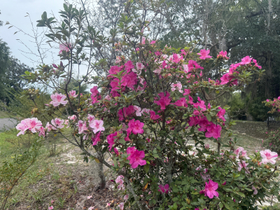
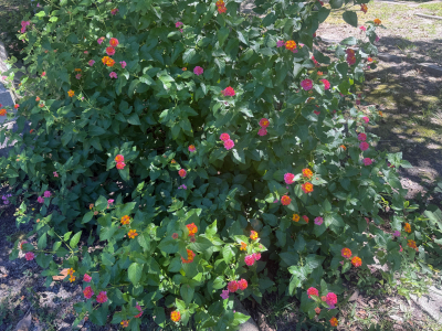
Busy squirrels, late summer flowers and old, old gravesites at Oakdale Cemetery, Wilmington, NC, September 2025.
Last week I posted on this Internet site a report of my paddle to Masonboro Island. A couple days after the trip, I had an insight of what had transpired which has become a watershed experience for me that greatly improved my kayaking situation.
For the first 50 years of my outdoor athletic career, I led small groups of friends and went on solo trips all over the Blue Ridge, Black and Smokey Mountains. Mostly we were backpacking, but we also did camping, hiking, canoeing, canoe camping, cross country skiing, snow camping, and even a couple kayak camping trips in the coastal estuary near Swansboro, NC. I often went to places which were new to me, to scope out routes for future trips. I was always well prepared and traveled carefully. My friends joked that if they were planning a trip, they would invite me, because I would bring the necessary equipment, like the first aid kit, fire starter and spare paddle.
During those times it was never my concern that I would get lost or injured. I always had a map and compass, and I knew what I was doing. If someone got lost or injured, then I was often the one to find or treat them. I did not ever need to be found or treated myself.
When I moved to the coast and lived in New Bern for a few years, and then moved to Wilmington and have lived here for a few years, I took up kayaking as my main sport. For some reason that I do not know why, I became overly cautious. When kayaking, I always went with a group – never solo. I usually followed an experienced paddler as a guide. I had a good GPS, and several smart phone mapping and navigating apps, but I feared getting lost. I was constantly concerned about capsizing and not being able to do a self-rescue.
After this Masonboro trip last week, I amazed myself by realizing that during the entire paddle, I had not once been concerned about being solo. I did not think about not having a guide. I traveled to several places new to me, using my GPS, and I was always well aware of where I had been, where I am, and where I am going. The potential of capsizing and needing a self-rescue never entered my mind. This personal growth was not something that I was planning or working on specifically. It just kind of happened naturally.
I still prefer to paddle with partners, and I will welcome a guide. But the new found freedom I feel from not being tied to always searching for partners and guides is refreshing. The ability to navigate to new places with just my GPS is encouraging. Of course, I will not go crazy. When I have the opportunity to do a longer, more exposed paddle, like from Beaufort to Shackleford Banks, or from Harkers Island to Cape Lookout, I will only go with experienced partners and guides.
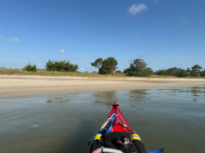
On September 6 I made a paddle trip to Masonboro Island south of Wilmington, NC, to explore and find a suitable site for hopefully many return kayak camping trips. I launched from Trails End Park about 8 a.m. on Saturday morning. The lot was completely packed – every parking space was full, mostly with pickup trucks pulling motor boat trailers. More traffic was backed up circling the lot in line to unload or load boats at the ramp. I finally had to squeeze my Jeep into a space between two trucks that had about an inch to spare on both sides.
Besides my boat and all my paddling gear, I was carrying a large, heavy load of water in my deck bag. It was a tiring job to hand carry my equipment across the big parking lot to the kayak launch dock. I could have used my wheeled kayak cart, which was in the Jeep, but I did not want to go to the bother of lashing it to the boat with multiple straps.
The conditions were nice. I had checked the weather and tide the night before, and put into the Intracoastal Waterway at high tide with no tidal current, no wind, no natural waves, and sunny sky with warm air that was just pleasant but not too hot.
I first paddled to the south, to check the land behind a couple of beaches I had seen the week before.
The first half of the trip was a little rougher than I expected. I was passed closely by many large, fast boats. A few boats politely throttled down to reduce their wake hitting me, which I appreciated. But the majority of the boats did not afford me that courtesy, leaving me bobbing and rolling in their heavy waves. Then, when I pulled up to the several beaches to explore, I had to situate my boat parallel to the shore right at the sand, so my feet could touch the bottom on both sides of the boat, and I could step out while keeping my balance. That orientation was not good. The boat wake waves hit me broadside, causing my kayak to roll nearly 90 degrees. And, the boat hull scraped the dirt bottom, pushing the boat even further into a roll. I had to quickly develop a new technique to exit the boat, using my paddle on the water side as a crutch.
The land behind each of the beaches as too low and wet on which to camp. At a few places, I walked through the swampy areas to the woods behind, and found brush too thick with no open space. So, I launched again and paddled north up the ICW to some larger beaches I had seen at home on Google Earth.
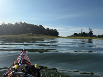
I turned east into a broad channel entering the sea grass beds of the estuary. From there a little to the south I found a half-moon bay on the ICW side of Masonboro Island, facing into the estuary. No boat wakes and no waves. The land behind the bay sloped up into a nice dune, safely above high tide. On the other side of the dune was a steep bank, protecting the site from any action on the ICW. The dune was partially covered with several kinds of salt grass, which kept the ground firm enough to hold a tent stake. Then, between several bushes for wind protection, there was a broad flat place, about the size of a couple tents. Success!
The only thing this site lacked was a couple of tall, overhead trees to provide shade. After I camp here a few times, I will come back to explore further north for some shaded sites.
I marked the location with a Waypoint on my GPS. After admiring the view in several directions, I took a short cut angling across the ICW back to the marina on the mainland, and then south along the shore to the put-in / take-out dock.
By now, the air had gotten hot. I had another long, sweaty, hard job hauling my gear across the big parking lot. When I was ready to leave, the lot was in gridlock, I had to wait 25 minutes for the traffic to move enough for me to head out homeward. Note to self: never come back here on a Saturday morning.
Late summer flowers; early fall leaf colors; old, old grave sites; Janet; Gracie and live oak trees in Oakdale Cemetery, Wilmington, NC.
Carolina Beach State Park Hike and Beach
On the nice, sunny, warm and breezy Labor Day of September 1, Janet, Gracie and I went for a hike and played on the little beach beside the Cape Fear River at the junction with Snows Cut in Carolina Beach State Park.
Being the Labor Day holiday, the park was packed with visitors and vehicles, mostly pickup trucks with motor boat trailers. When we arrived, we joined a crowd of other vehicles parked beside a road near a parking lot. Immediately, a Ranger walked up and said our space is illegal to park - we had to move to a paved, painted parking space. Of course, there were none open. And, there were many other illegally parked vehicles scattered all over the park which did not move. We eventually moved to a grass field with a sign, “Only For Boat Trailer Parking Overflow.” We parked there anyway and nobody bothered us. Later that afternoon, when we returned to our vehicle, we saw that none of the illegally parked vehicles had been ticketed, towed or moved.
At the small beach beside the marina, there is a small Caribbean looking kayak and SUP rental business. The manager very kindly placed in the front a bucket of sticks collected for dog owners to take and throw in the water to their dogs. So, we took a few sticks and threw them in the Cape Fear River to Gracie, which she joyously retrieved.
We then took the Sugarloaf hiking trail through the center of the park. All went well.
When I was at our parking lot, I noticed that the water in Snows Cut was flowing towards the southwest. My GPS showed the tide was rising, which seemed backwards to me. I sent an email query to several paddling friends, who informed me that the main flow of water into the Cut on a rising tide is from the Intercoastal Waterway to the northeast, rather from the Cape Fear River to the southwest. Phenomenon explained.
Fellow paddlers and campers.
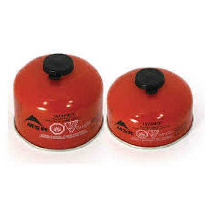
For those outdoor adventurers who use gas canister stoves and lanterns, it can be difficult to know how much gas is left in a partially used canister.
Please see below a chart I made to show the amount.
You will need access to a small weigh scale which measures ounces or grams.
Canister fuel chart:
Small canister full = 7.4 oz / 210 grams
Small canister empty = 3.5 oz / 100 grams
Large canister full = 13.1 oz / 372 grams
Large canister empty = 5.3 oz / 150 grams
Bob.
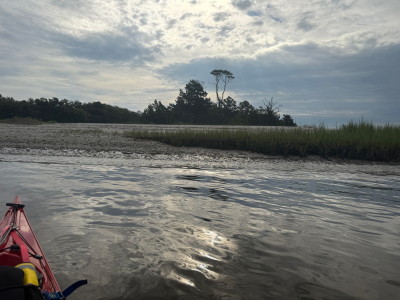
Masonboro Island with Wilmington Paddlers
On August 30 I joined the Wilmington Paddlers club under the able leadership of Gabrielle on their trip from Trails End Park to Masonboro Island. Being as it was Saturday morning of Labor Day weekend, and the Trails End parking lot is usually packed with pickup trucks hauling motor boats and trailers, I arrived early, at 7:30 a.m. I got lucky and found that nobody had parked in the best spot right beside the launch ramp, so I took it.
We put in right at the bottom of low tide. Most of our approximately ten paddlers were on stand up paddle boards. There were two other kayaks, being a sit on top and a fishing boat, both with flat bottoms. My kayak was the only one with a sharp V hull, which meant it took the most draft (water under the boat to float above the bottom). As a result, my boat dragged several times on the sand bars and mud flats at low tide. On one mud flat, I could see the bottom was several inches under water, but I kept having a very hard time pushing past the flat. After I got to the other side, I felt my rudder handle and realized it was down. I had dragged my rudder through about 50 feet of mud. Duh!
We ventured into the Intracoastal Waterway, and turned south, paralleling the western edge of Masonboro Island. We passed two small sand beaches with trees behind them, which I noted as potential camping sites. Then we turned east and entered the myriad narrow, winding water leads through about a mile of sea grass beds between us and the dry ground of the Atlantikc Ocean beach on the other side of the Island. Several paddlers made suggestions of where we should go. But eventually we ran out of water and came to a dead end.
Again, several paddlers made suggestions of where to go next, and the group agreed to return to the ICW the way we had come, then go north and play at some larger beaches. Somebody named a fellow paddler (not Gabrielle) and jokingly said that she is now the leader. The lady commented that she does not know this area, but she bravely stood tall on her SUP and scanned the horizon. Soon she ventured in a chosen direction, and we all followed her.
I had not memorized our route from the ICW into the estuary, since I intended to follow the leader, but my instincts told me we were going too far to the north, and not far enough to the west. So, I checked my GPS, and changed the screen from marking waypoints, to track back. Sure enough, we had missed our first turn by about 150 yards and were going about 90 degrees too far north. In some open water situations, being 150 yards off course is not a big deal. But in this sea grass estuary, where some of the channels are only 10 yards wide, 150 yards off course can mean being lost for a good while.
The other boaters were about 75 yards ahead of me. I blew my trusty whistle to get their attention, pointed with my paddle in the correct direction, and paddled that way. To my somewhat surprise, they all followed me, since none of them knew me, or whether I was a good navigator. After a while of leading the group, then I got into trouble. I reached a point where my GPS said to turn right, but there was no open water way that way – only grass and mud. So, I kept going straight, and each time I came to a potential turn, I kept angling to the right to attempt to get back onto our route.
Then I got lucky. I came to a long, straight channel and at the far end I could see the ICW. So down it we went.
As we progressed north up the ICW, I passed one of the small beaches which may be a good camp site. I paddled over to the edge of the water, parallel to the shore, and took some photos. Unbeknownst to me, a large boat was fast approaching from my rear. When the first wave from its wake hit me, my boat rolled about 60 degrees and I nearly capsized. Two more waves rolled under me while I frantically hit the water with my paddle in a high brace. In a few seconds, I turned my bow to meet the waves head on and get stable. This event was the first time my boat had rolled far enough over for the water to go past the cockpit rim and get onto the spray skirt; and the first time I had prevented a capsize with a high brace.
I was concerned that if we went back into the estuary later on the trip, my boat would continue dragging. So, as the group continued north, I turned off to the west and took out at the boat ramp. Later in the day, several paddlers posted trip photos, showing they got to several nice beaches on a small island on the east side of the ICW, and then they made it to the ocean beach. One of the posts showed their route. It was near what appeared to be a wide, straight channel from the ICW to the ocean beach, avoiding winding through the estuary.
I plan to return soon to Masonboro and disembark at the two small beaches across the ICW from our launch site, to walk on the land and look for places to pitch a tent. Then I will explore the larger beaches to the north which may have good camp sites. Then I will explore the large channel leading to the ocean beach for more camp sites.
Lees Cut Comfortable Paddle
On August 28, Janet Smith and Bob Laney drove with our kayaks to Lees Cut at the north end of Banks Channel on the sound side of Wrightsville Beach, N.C. Our put-in and take-out were the Wrightsville SUP shop beach. My plan was to make it a quite comfortable paddle so as not to push Janet or me on a casual day. My Montana GPS reported we traveled 1.8 miles in 1.5 hours.
Besides the short distance and time, another comfortable factor is that, unlike out last several trips to Lees Cut, the weather conditions were with us instead of against us. The air was sunny and warm. The water was warm. We paddled at high tide, making for almost no current. The mud bottom paths through the sea grass estuary were full of water and traversable. And the wind was a manageable 5 to 7 miles per hour.
Last year, I pushed Janet to stop paddling her Old Town 10 foot long and very wide fishing kayak. She let me get her a Wilderness Systems 13.5 foot long Tsunami, which is much sleeker and faster. I wanted her to be able to keep up with my Eddyline Sitka XT 15.5 foot boat. Unfortunately, Janet needs more room to stretch out her legs, and occasionally trail her feet in the water. So, for the first time in a year, she switched back to the Old Town. Things went well. She paddled easily and dragged her feet in the water. We stayed reasonably close together.
We lollygagged through and around the sea grass island in the middle of the Cut. Then we explored to the ends of several small bays on the north and east sides of the Cut. Everything was pleasant. On our way back to the Wrightsville SUP shop’s beach, we passed several seagulls floating on the seawater, which I had not seen before.
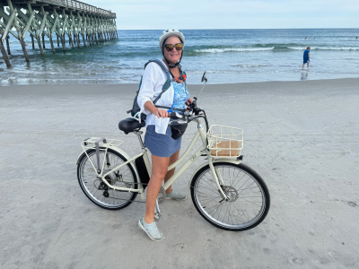
Wrightsville Beach Swim and Bike
On August 27 Janet and Bob took a pleasant trip to Wrightsville beach at Johnny Mercer Pier with our chairs and bikes. The conditions were the most gentle and pleasant I have ever experienced on the ocean shore.
The sky was blue with bright sunshine. The tide was a couple hours before low tide, so it was going out, and no problem with the waves getting up to our beach bags. The water was quite clear and there was almost no wind. The sea bed was firm sand with no drop offs and sloped down gradually towards the ocean for 100 yards. There were no sharp shells, the waves were small, and the water was just cool enough to be refreshing. Most of the area schools started this week so the beach was uncrowded.
After soaking in the water for a while, then soaking up some sun rays for a while, we rode our bikes on the sand southward to Crystal Pier. There we had a late afternoon supper of shrimp tacos with a Red Oak beer for Bob and a beef hamburger with lemon water for Janet. Due to the imminence of sunset, we rode our bikes on the road back to the parking lot with our Jeep.